
Imagine yourself stuck in traffic with the inability to move. You’re tired and hungry, but unable to get to your house, restaurants, or stores. Now imagine yourself on clear streets with easy access to anything you need close by. Similarly, fish thrive in waterways where they can move freely and food, shelter, spawning grounds, and rearing habitat are readily available. In rocky streams, channel complexity involves having abundant pools and riffles, logs offering shelter, clean gravels, streambank growth, and side-channel habitat. Excessive fine sediment (clays, silts, and sand < 1 mm diameter) threatens this complexity, limiting habitat. In fact, the US EPA classifies excessive fine sediment as a pollutant and streams identified as having excessive sediment are listed for remediation.

Figure 1. Fish are happier with greater channel complexity.
So how does excessive fine sediment impact fish habitat? For rocky streams, excessive fine sediment impacts stream habitat by plugging the voids between gravels and cobbles and changing the streambed shape (Figure 2). Plugging voids between gravels and cobbles eliminates vital refuge for juvenile fish to escape predators and is the home to many important insects. Pluck a rock in a riffle with “clean” gravels and cobbles and you will find mayfly and caddis nymphs and larva crawling around. The insect buffet is open for a stay-at-home meal! Do the same where fine sediment is filling the voids and you will see very few, if any insects present: the cafeteria is closed.
For spawning fish, the excessive fine sediment can “lock” gravels in place making it harder to move the gravels when forming a spawning bed or redd. Once a redd is formed and eggs laid, excessive fine sediments can plug the voids reducing the oxygenated water flowing through the redd which nurtures the eggs within.
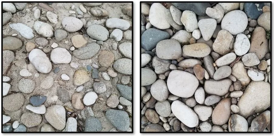
Figure 2. Gravels and cobbles: plugged (left) versus clean (right) of fine sediment.
Broadening to the stream section, excessive fine sediment can change the streambed shape (aka stream channel morphology). Over longer periods, stream channels act as a conveyor belt, moving water and sediment downstream, and have adjusted their shape to efficiently move this material. Lane’s Balance is a great way to illustrate the balance between stream shape and sediment characteristics (Lane 1955). For channels in equilibrium, the sediment load and size of streambed material are proportional to the water flow and streambed slope (Figure 3). So, if water flow and streambed slope remain constant and more sediment is added, the scale tips to the left and the arrow points towards depositing sediment (aggradation). Aggradation happens because the stream does not have sufficient power to move the increased sediment load. The resulting deposition covers gravel bars, fills pools, and widens and decreases the channel width and depth, thus decreasing the complexity of the stream channel morphology. In addition, these changes can increase stream temperatures as more water surface is exposed to the sun.

Figure 3. Lanes balance for the streambed equilibrium (Lane 1955). Image source: Rosgen (1996)
Excessive fine sediment added to a stream is bad, but what are the sources? In a stream section, there are 3 three primary sources that could supply sediment:
Upstream flow carrying clays, silts, and fine sands that deposits locally.
Streambank erosion of exposed soil on the streambank that is being eroded away by water (scoured); or a streambank that is likely to or has collapsed, creating a bare and near-vertical face.
Surface runoff filled with fine sediments from fields, roads, stormwater drains, construction sites, etc.
In a watershed, one or more of these factors can be at play in the same reach. The difficulty for water management agencies and conservation groups is identifying these sources across the landscape. Aerial photographic studies and field observations by agency staff are typically used but are costly and limited. Citizens can assist in the effort by helping to identify and notify where streambank erosion and surface water runoff are contributing to excessive fine sediment.
How can you help? Using the WiseH2O mobile app, you can help identify and tag sources of fine sediment. For further information on how to get involved, go to https://www.mobileh2o.com/mh2oapp.
Until next time,
The MobileH2O Team
Sources
Lane, E. W. (1955) The importance of fluvial morphology in hydraulic engineering. Proceedings, American Society of Civil Engineers, No. 745, July.
Rosgen, D. (1996). Applied River Morphology. Wildland Hydrology, Lakewood, Colorado.